
The Zion 100K ultramarathon was held April 12th, just outside of Zion National Park in Southern Utah. The start and finish is in Virgin, UT. The 100k course was changed this year and I’m assuming it will stay in this current form next year as it worked well I think. I ran this race over a month ago (partially due to 3 hours of work on this report being erased somehow) so my memory might be a bit fuzzy but I think I can give some good details. Lots of pictures with this report at least.
Since I didn’t get into Superior 100 this year I needed to quick find a race that would qualify for Western States as I still haven’t won the lottery for that race. The 100k version of this race (also available are 100 mile, 50k and half marathon options) qualifies for Western States and wasn’t full yet. Also I’ve never been to Southern Utah and wanted to check out some of the national parks with my wife to see if we’d want to come back when the kids are older. I hadn’t run a 100k distance race yet either, so that was of some interest to me as well.
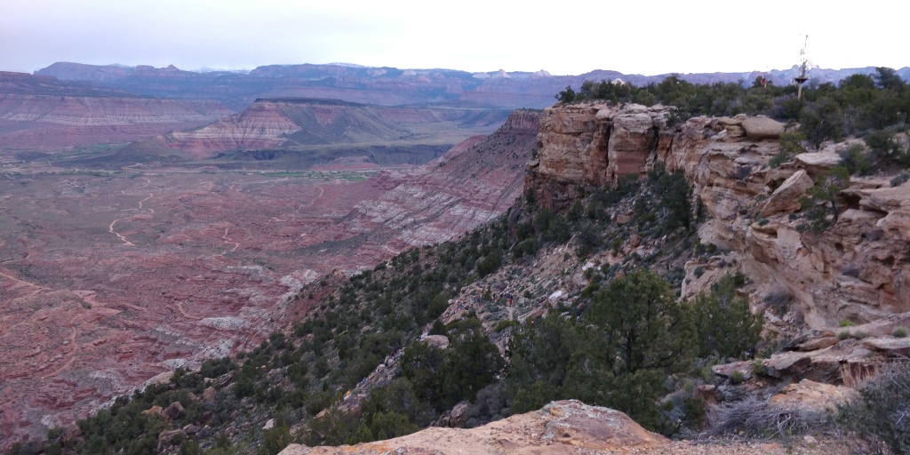
We left Minnesota a couple days early so we’d be able to explore the area. This ended up being perfect timing as the blizzard hit a few hours after the plane took off. We landed in St. George and went straight to Paria Valley in Grand Staircase-Escalante National Monument. I’ve wanted to go there for years after seeing a photo of the place. I kept this part a surprise for my wife since I didn’t want her to know what it looked like before we got there. It was cloudy but soon after we got there the clouds parted enough for me to get some great photos. People keep using my photos without giving credit so I’m not going to put any of those on here since they’re good enough to be worth something. It was worth the drive I think. Along the way there were some towns we drove through. It was interesting to us to see lots of homes with no siding whatsoever. Basically people just painted the OSB sheeting and called it good. I guess in the desert that’s okay?
We stayed in Hurricane, UT at an AirBnB. Turns out everyone staying at the place was in the race or a crew for a runner. It certainly made us not feel so bad getting up super early on race day. We ate some awesome Mexican food and went to bed.
The next day we went to Zion National Park. I wanted to go up Angels Landing and even if I didn’t want to, there was basically no other choice. Essentially every other trail in the main valley was closed due to flooding or landslides. It’s about 2000 feet of elevation gain total and close to 5 miles round trip but I wasn’t too worried since the race was only supposed to have 5500 feet of gain which is pretty flat. The trail is a steady climb for pretty much the whole way to Scout Lookout which is where the trail gets “scarier”. I wasn’t too surprised when my wife decided not to continue since the going down part would be scarier than going up. It’s not anywhere close to as scary as half-dome in Yosemite but if you’re not used to hiking along cliffs, you’ll be concerned.
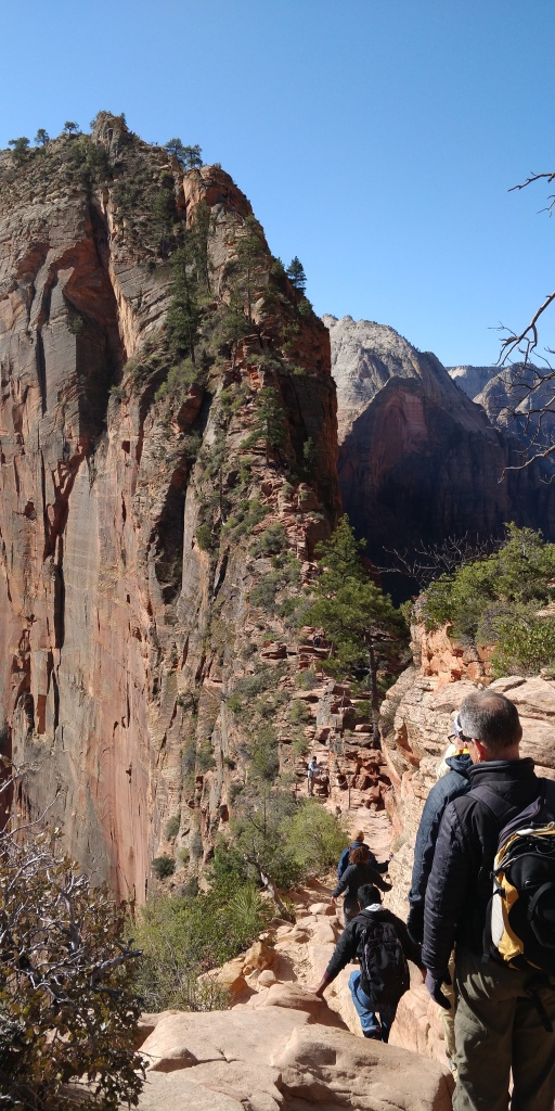
There are chains along portions of the trail to hang on to but I just used my hands to hold rocks instead. It was much faster that way and the chains moved around a lot. If it wasn’t for crowds, you could run most of the flat parts really. Same with going down, if no one was around you could get down pretty quick. I hung out at the top for a little while to enjoy the views and take some pictures.
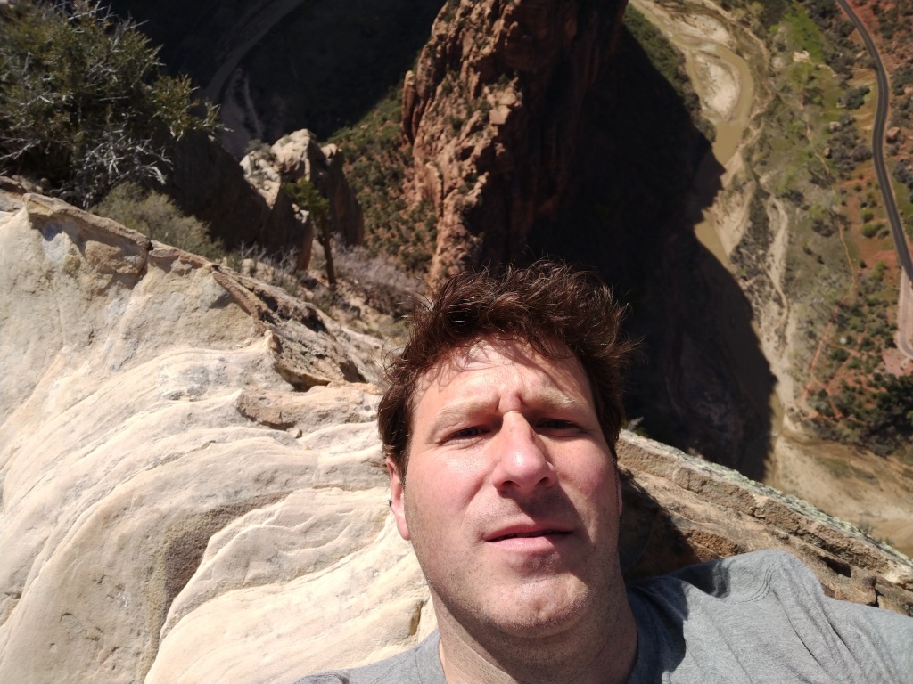
On the way down I saw at least one Condor. We couldn’t quite read the number on his wing to look it up later but it was pretty cool it flew so close over our heads and beside us that we could even see that at all. It was 2 digits but I think they’re all just 2 digits and then color coded. This one seemed orange or yellow. The sun kept blinding us. There’s still less that 300 of them in the wild! My wife I think saw it from the landing as well. Of course since I spent so much time watching the bird she was concerned about me by the time I got back to her. Oops. The rest of the day was pretty much spent relaxing, getting my bib, and getting everything finalized for the race the next day.
The race started Friday at 6AM. The 100 mile and 100k started at the same time so there were hundreds of runners. Since it was still dark, I needed my headlamp. We ran on the shoulder of the highway for a bit and then dirt roads headed toward the first and only big climb of the race. About 3 miles into the race is where it starts to get steep and just gets steeper. I wasn’t really in the front group but was towards the front. Somehow a group of people after the front runners took a wrong turn and we all followed up the wrong trail. After going up a couple hundred feet we saw people running back down saying it was the wrong way. So back down I went and now it was of course super crowded since we were just running into the people behind us. Surprisingly, people hiked up the correct direction at a decent pace so I didn’t have to stop and start all the time like I did at Bighorn waiting for people to move. Finally after about 1200 feet you get to the top.

Here is the first aid station called Goosebump. We’d go through this station 2 more times later on and there is no crew access here so it’s the only place I left a drop bag. I got here in just over an hour so not too bad.
From here to the next aid station which was Grafton Mesa was pretty much flat. It was all on dirt road with a downhill at the end. I talked to a few people along this section and realized I wouldn’t need my poles for the rest of the race. There was a chance of rain forecast initially but it looked like that probably wasn’t going to happen. I was fairly hot already since I was still used to winter weather at home. It wasn’t all that hot, probably only got up to 70 degrees and sunny but I was feeling it pretty much the rest of the day. I also was feeling like the hike yesterday was definitely going to slow down my time. My legs just felt kind of dead all day.

I found my wife at Grafton fairly easy around 8:10AM. I got some ice water from her, changed into a t-shirt from a long sleeve shirt, got food, left my poles and told her I’d see her later. We went through this aid station twice more so she just stayed there and read. The race continued on down the road until Wire Mesa where we went onto a mountain bike trail. There was an aid station at the start of the trail and we’d loop back to it before going back up to the Grafton Mesa.
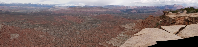
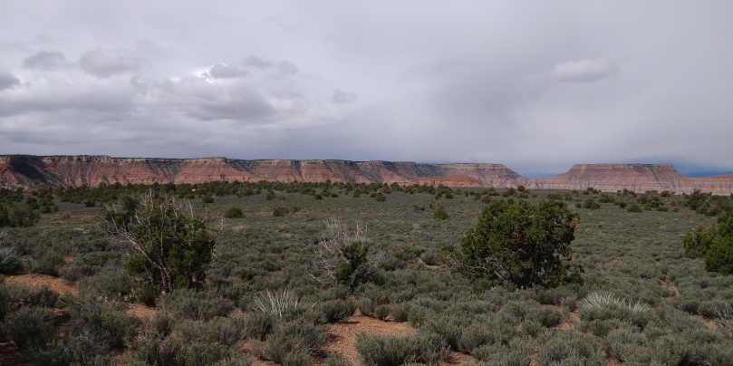
Wire Mesa is the closest mesa to Zion National Park. Basically it’s just Southwest of the entrance to the canyon so you can see some of the peaks in the park. The mesas themselves are gorgeous though as well. The trail led all over the mesa and the edges of it. The views from every edge were great. I heard several people overwhelmed with the views. They were full on swearing in disbelief for minutes at a time. I was starting to wonder if they’d ever been outside in their entire life.

The trail itself was overall flat but you were going up a rock here and down a rock there almost every 2 steps. It got annoying and it was starting to dawn on me why the previous finishing times of this race were longer than I expected them to be based on the distance and elevation gain advertised. It took about 90 minutes to complete the loop.
During this mesa section I realized I’d need to use the bathroom at some point. I saw there were 2 compost toilet tents at the aid station the first time I went through. I also saw there were about 7 people in front of me on the trail when we were nearing the station. I didn’t want to risk having to wait for all of them to use it first so I sprinted downhill past them all and went straight into the toilet.
Okay, this is going to get gross. I’ve stopped talking about pooping in my reports due to comments but this I can’t skip over.
So to start with, here’s how the race advertises these compost toilets in the race booklet;
We also use Great Outdoors Composting Portable
Toilets which conserve water, eliminates the use of
harmful chemicals, and create a nutrient rich soil
amenity. It is the best pooping experience you will
ever have. To learn more about Great Outdoors
Toilets or to have them at your event visit www.
greatoutdoorstoilets.com or ask the race officials
for more information.
The best pooping experience you will ever have you say? No! You’ll be talking about it for sure, but not because it’s great. I don’t have a picture of these since I never wanted to get close to them again, so I’ll do my best to paint a picture with words. You could go to their website, but they smartly don’t show you pictures of the inside of the tent version they had at the race.
The compost toilet consists of a wide plastic bucket with a 3/4 inch thick piece of plywood placed on top of it with a hole cut out. They did add a toilet seat to this board so there’s that I guess. This board was about 2 feet wide and the depth of a toilet seat. This was all surrounded by a shower tent like structure. Look it up if you don’t know what I mean. This tent however was much smaller than a shower tent which is tiny to begin with. Basically if you were over 6 feet tall, your knees would be touching the tent wall when you sat down and your head hitting the ceiling. The zipper was also under a lot of tension so it was basically impossible to close all the way from the inside due to the tight space. I suppose you could’ve walked in, put your face down in the seat area bending over and put your hands through your legs to close it? I wasn’t going to try that.
But I’m getting ahead of myself a little. There is sawdust already pre-moisturized that you’re supposed to scoop from a barrel outside this tent and spread on top of your deposit to the plastic bucket. One scoop for pee and two for poop I think the signs said.
Anyway, when I got to the aid station a guy just came out of the tent and I went right in…. Remember when I said it was sunny and kind of hot? Imagine a greenhouse filled with poop, wet sawdust, urine and zero air flow. That should paint the air temperature and smell for you. Then the sights, oh the sights. Toilet paper, sawdust, and what I can only assume was poop all over the seat and plywood. If you put a dog in similar conditions, you’d go to jail. It wasn’t quite as bad as the scene from Rambo where he’s being hung in the waste water from the outhouses, but my mind immediately went there.
There was no way I could do all I needed doing while holding a single breath, especially after sprinting downhill to get there. My breath number was definitely in the double digits. I went as quick as I could and did a horrible job of applying more butt lube since there wasn’t any room in there and I didn’t dare let my pack touch any horizontal surface. That would certainly haunt me later. I was seriously considering just opening up the “door” and doing everything in full view of all the runners coming down the trail and the people eating at the aid station. Why should they be punished though, they were probably smart and just pooped on the course somewhere.
The first breath of fresh, cool air after you exit is about the best thing you can imagine. That is until you realize you have to go back in not only once, but twice, to sprinkle sawdust on top of your carefully crafted cupcake. Why can’t you just make a bigger scoop?! Even though I kept my hands clean, there was no way I could say they were clean after touching the tent itself, anything in it, or the scoop. I had a worker push the plunger on the water spigot so I didn’t contaminate it and didn’t get any food. I still had some of my own left anyway.
How is it even legal to compost human waste? That means it’s sitting out in the open for weeks. Truly one of the worst pooping experiences I’ve ever had.
After this I continued on back up the road to Grafton aid station. I found my wife in the same place and briefly described my experience. She said she heard some of the toilets at that aid station had poop up to the toilet seat already. She smartly never went into one. I got ice water and soaked my head with water.
The next part of the race was to run a 5.5 mile loop on the Grafton Mesa. There was a short section in the beginning that both directions ran on so I saw there were a few people already finishing the loop. It was a little nicer trail that the last one but the views weren’t quite as nice. Basically you ran a gentle slope towards the end of the mesa and then back up to the aid station. It was getting much more thinned out now. While I could see someone all the time up to this point, now it was only about half the time.

I was now starting to slow down as I was hitting the marathon distance in this section and the heat was getting to me since it was almost noon. I lost some time in this section but I just had to remind myself this is pretty normal at this point in a race. I got to the Grafton aid station for the last time and reloaded a fair amount since I wouldn’t see my wife for over 5 hours. She went back to the Airbnb and I think even took a nap.
I tried to make up some time on the road back to Goosebump with some fast walking uphills. It seemed to take much longer this second time running on this section. The views were nice though and soon enough I got to the aid station at 12:52PM having made back the time I lost on Grafton. There was now less than 29 miles left.
The next section was an 11 mile loop on Gooseberry Mesa. We started out on the North edge of the mesa going West. The trail was right on the edge of the cliff for the first mile or so and was gorgeous. The best views of the race!

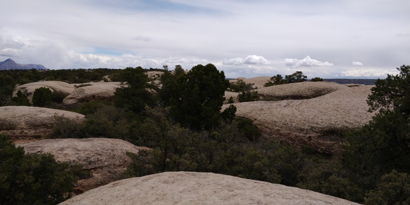
After about 20 minutes I got to the “slick-rock” area. It wasn’t what I was expecting at all. At home, slick-rock is flattish smooth rock. What they called slick-rock here was petrified sand dunes. They weren’t slippery at all due to being sandstone and they certainly weren’t flat. Best to just show a picture.

I’ve never gone mountain biking so I’m not sure if they like to curve all over the place when they ride or they’re just drunk because these trails never went straight. Up to this point the biking trails we were on were classified as Easy or More Difficult similar to ski slope ratings. We were now getting into Difficult and at several points I noticed a rating of Extreme. I’m assuming that’s like a double black diamond in skiing. Regardless, in the photo above I’ll try to explain how the trail went. You go up and over the left part of the dune in the middle of the photo. Then up the left part of the dune behind it. Turn around and go back down to the back side of the middle dune but only go part way up it and then down and then up the right side of the dune behind it. Then turn around to go down and then up and over the right side of the middle dune that you can’t see. Then back up the backside of the dune on the right. All of that instead of just turning right at the middle dune! Now it’s been a month so I might be off slightly in my description of that small area but it was pretty shocking so I think I remember it pretty well.
So how did I know where to go? Well the race course is marked with those little pink ribbons you can see on the tree on the right, but since there aren’t that many trees around and you can’t stick a flag in rock, they are somewhat far apart in this section. The bike trail is marked with white dots of paint. This is what the race book stated about them:
The trail will be marked with pink ribbons.
Note that sections of this trail may also have
markings of white dots painted on the slickrock.
These white dots are markings for mountain
bikers. Even though some of our course coincides
with the mountain biking trails DO NOT FOLLOW
THE WHITE DOTS. Our course will veer on and
off the mountain biking trails- just make sure
to follow the pink ribbons.
The big joke was that if you didn’t follow the white dots, you’d have no clue where to go as you couldn’t see the next flag from the one you were at without following the white dots. There were maybe 2 places on this entire mesa where the trail turned off the bike trail and there were lots of flags in those areas to make sure you made the turn. Otherwise if you didn’t follow the dots, you’d get lost. Plus they’re on the ground and much easier to follow than the flags 4 feet up in the air.
Occasionally I could see the next flag across an area of these hills but even then I followed the trail instead of going straight to it. I don’t know if it was cheating to cut straight across or not but I saw people doing it. Really I don’t think you saved hardly any time doing that unless you knew the course really well. Sometimes the hills had steep dropoffs and some were sloped. The white dots never went off a cliff and stayed on the sloped area.
Clearly this section was going to take a lot longer than I was planning. The elevation profile advertised for this area was a gradual elevation gain towards the turnaround and then gradual decent. Of course going up and down 5-8 foot hills constantly adds a lot of unmeasured elevation gain and technical difficulty. Here’s another picture of the sucky-suck that was the slickrock.
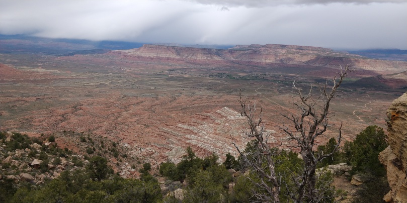
After an hour of these hills, I made it to the turn around spot at the end of the mesa. The views here made it worth the effort if you’re ever in the area. You could see pretty much everything from here.


I kind of caught up to a few people in this area. We laughed while telling each other not to follow the white dots since we clearly had no other choice. We were now skirting the South rim of the mesa. The views weren’t quite as nice but still beautiful.


There was an aid station called Gosseberry on this section but I didn’t know how long it would take to get there. We were again in sand dune land. At least I had some company to laugh with about the insanity of going up and down hills. These hills seemed bigger and steeper. We quite often saw scratches in the rocks from bike frames being scraped along them due to the steepness of drop offs. It ended up taking about an hour to get there. It was mid-afternoon and sunny. Not great for me, but since it was such slow going anyway I wasn’t too overheated. The best thing about the aid station was that I realized the only way they could’ve gotten all that stuff there was if there was a double track a truck could go down to deliver it. Sure enough the trail got much better!

After a bit, I could see the windmill that was visible from the road going to Goosebump from Grafton. I knew we had to be getting close to the Goosebump aid station. I arrived there at 3:40PM, almost 3 hours for a loop I thought would only take about 2.5.
I spent a little extra time here to tighten my shoes for the steep decent off the mesa. I reloaded and got some food loaded up since it was over 8 miles to the next aid station where I could finally see my wife again. I placed my drop bag in the “return” pile and started off down the hill.
The trail was right at the edge of being too steep to run down and since it had lots of round rocks that liked to roll, I just hiked down it to play it safe. My feet were almost always slipping down the hill but I maintained my balance and made it down fairly quickly.
I hadn’t really thought about what to expect in this section once I got down the big hill. I was thinking it would be fairly flat since it was off the mesa. Well not really. The trail was a double track that went along the North foothills of the Gooseberry Mesa I was just on a short time ago. This meant constantly going up and over hills to get to the next drainage off the mesa. Sometimes we’d follow the muddy creek beds up a ways, crossing the water multiple times before finally leaving that drainage just to go down another one. This played out for quite a while. It wasn’t really all that bad but just wasn’t that fun with tired legs.
Well, it was pretty bad in one way at least. Remember when I was in that hot box from hell earlier in the race and didn’t apply lube appropriately? Now things were getting chaffed fairly good. Since it was so dry, all my sweat just dried in place. It never soaked to the outside of my clothes like usual. This meant all the salt was still on my skin. I always have Vaniply with and I just had to apply that every hour or so to keep it at bay.
I saw a few pacers running the other direction. I’m assuming they were going to meet their runners somewhere up on Gooseberry since crew weren’t allowed there. They made the trail look easy. I was running out of water when finally the trail left the foothill area and got on a more flat area. I knew the aid station couldn’t be too far away. I got there at 5:34PM still about 20 minutes off pace. This aid station is where the 100 milers split to a different course from the 100k runners. I think there were a fair amount of 100 mile runners that called it quits here. I told my wife I was expecting to get to the finish line later than expected as I didn’t think I would make up any time.
Soon after I left the aid station I saw a race worker sprinting down the trail yelling at the guy behind me that he was going the wrong way. He must’ve been a 100 miler but he told the worker that he knew it was the 100k course and that he switched races. I didn’t know that was a possibility but it’s not that unusual to be allowed.
There was about 10 miles left in the race and it was generally flat to downhill. The course was on bike trails once again. The trail itself was nice and easy. There were a few small hills here and there while going over small drainage areas. The next aid station was only 2 miles away called Virgin Dam. I didn’t see a dam anywhere. It was a fairly well stocked station and had helpful volunteers but I didn’t need anything this late in the race and had plenty of water.
I’d pass a few people here and there and get passed by an equal number of people as well. I saw quite a few people with pacers which seemed a little odd since it’s such a short race and we’d be done before dark. In fact, that’s one of the perks my wife and I were looking forward to in this race. We’ve never been done with enough time to go back to the room, take a shower, and go out to eat in the same day I started a race. We were planning on going to a BBQ place in Hurricane that closed at 9PM. Yes, you read that correctly; They close at 9PM on a Saturday, come on Utah!
Since I was behind pace, I was expecting to finish around 7:50 so we’d be cutting it close unless we left right away from the finish line. While this race is called 100k, it was advertised longer at 63.5 miles which isn’t unusual for a trail race.
All the signs at the aid stations, including the Virgin Dam station agreed with my watch for distance. The trail got close to the Virgin River but never really got to it until the end of the trail and a water only aid station called Sheep Bridge. It was supposed to still be 4.1 miles to the finish line from there so I filled up with some water and again wet my head to keep cool. The course was now on a somewhat busy dirt road that went toward the highway into town. It crossed the river and I was mostly walking up the road. Since I still had almost another hour left, I was saving some energy for the last push.
Turns out I should’ve been running the whole time. Once I got on the highway, I could see the town just ahead. Even now, I kept telling myself the turnoff for the finish line must be at the other of town or something since this is nowhere near 4 miles. Nope, I was letting people pass me for nothing as just a mile or so down the highway was the turnoff for the finish line. I was happy but also kind of pissed I hadn’t tried harder the last couple miles. There was no way to cut this part of the course so I know I was on the right path, plus there were lots of runners around me. I finished at 7:15PM, ahead of my original goal time and a good half hour sooner than I was expecting at Virgin Desert.
My placing in the race kind of depends I guess. On the official site I’m listed as 51st, even though I was the 50th person to cross the finish line. They have the official results listed by chip time which I’ve never seen in an ultramarathon before. DUV has me listed as 50th since I was the 50th to cross. Whatever, out of 331 starters it was about where I expected to finish.
I got my medal and was just turning to head to the parking lot area since I was so early. I saw my wife just walking into the park. She was just as surprised as I was to see me so early. I laid down for a bit and then used my food ticket to get some nachos since we had so much extra time now.
We did indeed have plenty of time to eat nachos while talking to a couple other finishers, take a shower, and go to the restaurant. We were in bed by 10PM! Weird.
The next day I got up somewhat early since I can never sleep that well after a race. I went to get my drop bag that we of course forgot to get the night before. Then I picked up my wife and we went to the other valley in the Northwest part of Zion National Park and did a shorter hike to some overlook that wasn’t worth the effort. The valley itself would be cool but not in the morning. The sun was in our eyes trying to see the mountains. Afternoon would be much better. Our plane left that afternoon and soon we were home.
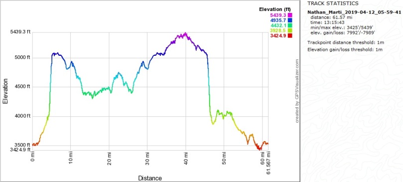
Runners only section: Not much else to say here other than the 5500 feet of elevation gain is way off. It was based on a watch measurement, and my watch actually agreed pretty close with that. Mine came in at 5700 I think but I did also do that extra hill in the beginning. My watch only records a elevation change if it’s over 5 meters and I’m assuming the race watch did as well. If you change the threshold to 1 meter to include all those little hills (mostly on Gooseberry Mesa) in the race, you end up with 7992 feet. I’m guessing it’s somewhat less than that but much more accurate to how the course “runs”. It’s fairly technical with plenty of rocks to trip you or slip under your feet.
I know a fair amount of people quit the 100 mile race in the night so I’m guessing those extra Mesas they run are fairly difficult.
If they continue with this course, expect that last section from the bridge to be shorter than advertised, otherwise everything was pretty spot on.
Follow the white dots or get lost.
Hurricane is quite close to Virgin, we stayed on the very Eastern edge of Hurricane and it only took 10 minutes to get to the start line.
It’s about as easy as a race can get for a crew. Very little driving and lots of time for naps.
Pretty much full sun exposure the entire race so if it’s sunny, use some protection of some kind.
I would definitely recommend this race just because of the beauty of the place. If you’ve had your fill of Southern Utah for some reason, then maybe not. I could see myself someday going back for the full 100 miler, not for a while though.
Race results here.

Thanks for sharing! I’ll be running the 100K this year, and I totally agree about those toilets. I was thankful for them at the Antelope 55K, and also desperate, but it was a rough experience. You had me laughing out loud!
LikeLike
Glad you enjoyed the report! Good luck!
LikeLike